Stories
The Greater Shanghai Plan: a new Chinese city centre at Jiangwan, 1927–1937
How Shanghai's Chinese government tried to build a city centre outside the settlements, what it finished before the war, and what still stands at Jiangwan.
Loading map…
North of the old city, around the five-way roundabout of Wujiaochang, stand a palace with a green roof, a library and a museum with yellow ones, a stadium with bronze cauldrons on its gates and a building shaped like a biplane. They are what is left of the Greater Shanghai Plan (大上海计划, Dà Shànghǎi Jìhuà): the attempt by Shanghai’s Chinese government, between 1927 and 1937, to build a new city centre of its own.
This story explains why the city wanted one, how far it got, and what you can still see.
A city run from somewhere else
In the 1920s the busiest part of Shanghai was not governed by Chinese officials. The International Settlement and the French Concession covered about 33 square kilometres in the middle of the city. They held the port and the business of the city, and they split the Chinese-run districts around them into three separate pieces.
In July 1927 the new Nationalist government in Nanjing made Shanghai a Special Municipality, with its own mayor and bureaus for everything outside the settlements. The first mayor, Huang Fu (黄郛), proposed a ring road around the settlements, a port at Wusong, and a new district between the two. His official Shen Yi (沈怡), helped him draft it and went on to drive the project under the mayors who followed.
The aim was more than tidiness. The new district was meant to rival the settlements, stop them from growing, and in time become the centre of all Shanghai. It was a plan to show that a Chinese government could build a modern city.
Why Jiangwan
On 5 July 1929 the city’s 123rd government meeting chose the site: about 7,000 mu, or 460 hectares, of farmland at Jiangwan, north of the settlements, between the Huangpu and the Songhu railway. The land was flat and thinly settled, so nothing old had to be cleared, and it had a railway and access to the river. From 16 July land sales there were frozen.
A committee to build the civic centre was formed about a month later, made up of the heads of the works, finance, land, utilities and harbour bureaus, with outside experts. Its money plan relied on the land itself. The first stage was costed at about 50 million yuan. The city would sell construction bonds, buy farmland cheaply, then lease or sell it once new roads had pushed its value up.
The plan came out in pieces. In August 1929 the city published a plan for the civic centre in three parts: transport by rail and water, a road network, and zones for government, business and housing, with the city hall, library, museum, stadium and hospital in the government zone at the middle. A plan for a new port followed, with docks on the Qiujiang (虬江), east of the civic centre, to be built in three phases; then a zoning plan for the whole city and a road plan of more than 20 trunk roads, about 500 kilometres in all. The full Greater Shanghai Plan map was drawn in November 1931.
A plan you can read in the street names
At the heart of the design was a cross of squares, over 500 mu, with the city hall in the middle, eight bureau buildings on either side, and a tower where the two axes met. From it the roads radiated in a ring-and-radial pattern.
The four main avenues were named after Sun Yat-sen’s political ideas. Sanmin Road, for his Three Principles of the People, ran west; Wuquan Road, for his five-branch constitution, ran east; Shijie (“World”) Road ran north; and Datong (“Great Harmony”) Road was to run south. Datong Road was never built. Sanmin and Wuquan Roads survive under other names, as Sanmen Road and Minxing Road. Beyond the centre the city also built Qimei Road, now Siping Road, and Huangxing Road.
The minor roads were named with characters from the government’s own title, 中华民国上海市政府, “Republic of China Shanghai Municipal Government”. About a hundred roads got such names. Walk around Jiangwan today and you are still on some of them: 市光路 Shiguang Road, 政立路 Zhengli Road, 国和路 Guohe Road.
A palace for a modern government
The city hall had to look Chinese. In October 1929 the city opened a design competition with a first prize of 3,000 yuan, and by February 1930, 65 Chinese and foreign architects had sent in 19 designs. Zhao Shen (赵深) and Sun Ximing (孙熙明) won, Wu Zhenying (巫振英) came second and Fei Libo (费力伯) third. None of them gave the government what it wanted. Dong Dayou (董大酉), the committee’s adviser, drew six new schemes from the top three entries, and the first of them was built.
The building he designed is a palace on the outside and a modern office inside. It is four storeys of reinforced concrete, about 93 metres long. The centre block has a hip-and-gable roof of green glazed tiles, the wings simpler hipped roofs, and the eaves rest on painted bracket sets copied from the rules for Qing imperial buildings. The columns that look like timber are concrete; the base that looks like stone is cast.
The builder Zhu Senji (朱森记营造厂) won the contract in June 1931, and the foundation stone was laid on 7 July. In January 1932 fighting broke out between Chinese and Japanese forces in Shanghai; Japanese troops occupied Jiangwan, and every building site in the civic centre stopped. The half-built hall, seven or eight tenths complete, stood idle until July. It was finished on 10 October 1933, the anniversary of the 1911 revolution. At 10 a.m. eight aircraft flew over scattering leaflets, and Mayor Wu Tiecheng (吴铁城) unlocked the hall with a key and spoke from his office balcony. More than 100,000 people came, and for the next three days anyone could walk through the building. On 3 April 1935 the square in front was used for Shanghai’s first collective wedding.
The architect
Dong Dayou was born in 1899 and trained in the United States, at the University of Minnesota from 1922. In 1927 he worked in New York for Murphy & Dana, whose Chinese-roofed designs for government buildings in Nanjing shaped his own. He came home in 1928 and in July 1930 became chief architect of the civic-centre committee.
Most of the buildings the plan finished were his. For himself, though, he built something else. In 1935 he put up a two-storey white modernist house on Zhengdan East Road, with curved corner windows, a swimming pool on the roof and a tennis court. Two years later his family was forced out by the war, and a Japanese commander moved in. The house was demolished in the early 2000s.
A library, a museum and a stadium
With the city hall done, the city built the institutions a capital district needs.
The city library and the city museum are twins, built side by side by the contractor Zhang Yutai (张裕泰): I-shaped blocks of reinforced concrete behind gate towers with double-eaved roofs of yellow glazed tiles. The museum’s gate tower shows its beams and columns; the library’s has low wings on either side. Money was short, and only about half the library was built: the plan was meant to resemble the character 井, with wings around courtyards, and stopped at the simpler 工. It opened on trial on 1 September 1936, with Cai Yuanpei (蔡元培) chairing its board. The museum’s board, chaired by Ye Gongchuo (叶恭绰), had gathered more than 20,000 objects by the end of 1936 and showed them in windowless galleries lit through glass skylights.
The municipal stadium was larger still. Dong laid out a stadium, a gymnasium and a swimming pool on about 300 mu, some 20 hectares. The stands were built for 40,000 people seated and 20,000 standing. Under them ran a corridor 870 metres long behind a ring of 120 brick arches with 34 entrances, so that 60,000 people could leave in about five minutes. Each grandstand gate was a three-arched stone pavilion topped with a bronze ding, the ancient ritual cauldron, to hold the torch.
The stadium was finished in October 1935 for the sixth National Games, which opened at 10 a.m. on 10 October with more than 2,700 athletes. It drizzled, and the crowd came in raincoats. The team from the north-east, by then under Japanese occupation, marched in wearing black mourning dress. On the track Liu Changchun (刘长春) ran 100 metres in a national-record 10.7 seconds.
Two more buildings came out of the same years. The China Aviation Association was founded in Shanghai in January 1933, a year after the city was bombed, to promote flying and raise money for aircraft; Mayor Wu Tiecheng sat on its board. It obtained 10 mu next to the museum, and Dong designed its clubhouse as a building shaped like a biplane, with nose, wings, fuselage and tail. At the top of the nose he put a round memorial hall around a three-tier white-stone altar, a small copy of the Temple of Heaven. Ground was broken on 12 October 1935 and the building opened on 5 May 1936. The city also built a municipal hospital and a health laboratory; the hospital opened in 1937.
August 1937
By 1937 the civic centre had its city hall and bureau offices, the hospital and health laboratory, the stadium, the library, the museum and 72 roads. None of it had time to work. On 13 August 1937 fighting began in Shanghai. Japanese forces landed at the new Qiujiang wharf, the plan’s own first port works, pushed along Xiangyin Road and took the new district. More than a dozen shells hit the city hall. The library had been open for less than a year; it and the museum were badly damaged, and the new hospital was occupied soon after it opened.
The occupiers kept Jiangwan, but for their own use. They drew up a city plan of their own, taking 16,414 mu around the civic centre, the wharf and Jiangwan, and by December 1941 had built a 7,000-mu airfield and 29 roads. In 1939 they burned the old town of Yinhang to make room for the airfield. The civic centre became their main garrison, with 28 military sites; the stadium was an arsenal, ringed with electric fences and bunkers, and the Qiujiang wharf shipped goods to Japan. They repaired the city hall, and on 16 October 1938 the puppet city government was inaugurated in it. Troops took apart the hall’s east gate portico and shipped a carved piece to Miyazaki, in Japan, where it was built into a “Peace Tower”. Dong’s own house became a commander’s residence, with horses stabled on the tennis court.
After the war
The civic centre was never revived. After the war the city government went back to the old commercial centre and left the plan behind. In July 1946 the ammunition still stored at the stadium exploded, starting a fire that burned for seven days and wrecked the stands. Planners did not give up on big ideas: in December 1946 a committee under Zhao Zukang (赵祖康) drew a new Greater Shanghai master plan for a region of 6,538 square kilometres, finished in its third draft on 6 June 1949, after the city had changed hands.
Its buildings found other lives. Shanghai University of Sport, founded in 1952, was given the city hall in July 1956 and still runs the university from it. Tongji Middle School used the library for about half a century as classrooms, dormitories and a gym. The museum, the aviation building and the hospital were absorbed into what is now Changhai Hospital. The stadium was restored in 1954 for 1.93 million yuan and renamed Jiangwan Stadium.
The repairs came slowly. In 1991 the Thai-Chinese businessman Zheng Zhongliang (郑钟良), treated at the hospital, paid 25 million yuan to restore the aviation building, now a university history museum. The stadium reopened as a public sports park in 2006, and the library became a public library again on 18 December 2018.
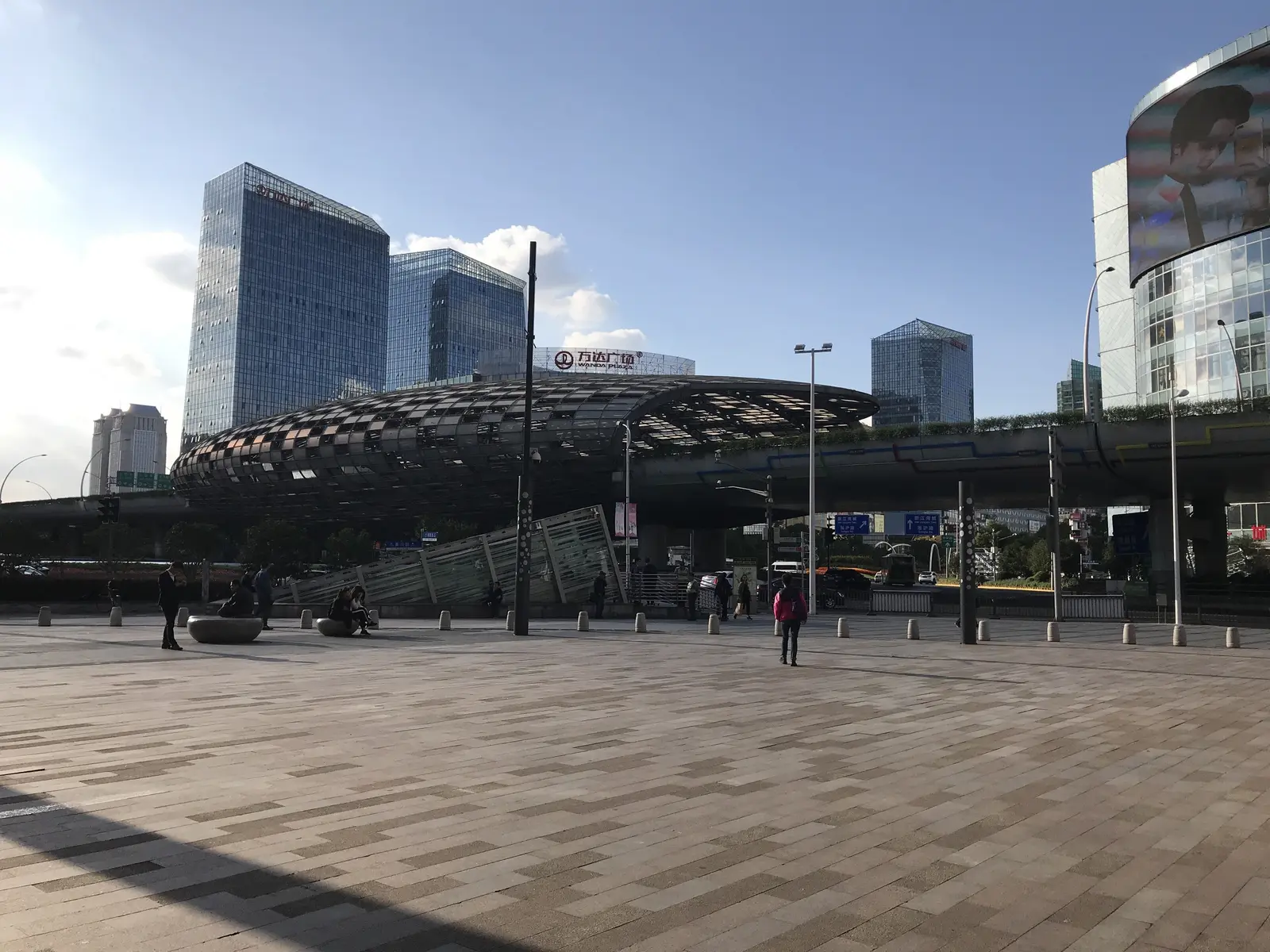
The plan’s road network outlasted its buildings. In April 1930 the city had cut Zhayin Road from the crossing of Songhu and Xiangyin Roads towards the civic centre, so that five roads met at one point; local people called it Wujiaochang, “five-corner ground”. Under the occupation the area’s centre of gravity moved from the city hall to that roundabout, where the Japanese put a headquarters. In 1991 the city’s master plan made Jiangwan-Wujiaochang one of Shanghai’s four urban sub-centres, and today it is a district of malls and universities.
Seeing it today
Take Metro Line 10 to Jiangwan Stadium station. At the stadium, look for the stone gates with their bronze cauldrons, the mottoes over the arches and the ring of brick arches outside the stands. Then walk east to Yangpu Library, the easiest of the buildings to enter: inside, the original peacock gate survives on the second floor, and the old catalogue hall keeps its skylight and painted beams.
North-east of the library, the green roof of the old city hall rises inside the campus of Shanghai University of Sport; visitor access to the campus is not guaranteed. East again is Changhai Hospital, closer to Xiangyin Road station on Line 8, where the airplane building, the old museum and the old hospital stand among working clinical buildings. Visitors report being able to walk in to see the airplane building from outside, but access can be restricted, and this is a hospital, so keep it short and quiet.
Places mentioned
Tap a name in the text, or “map” in this list, to see where it is; names with their own page link to it.
- 01Former Shanghai Municipal Government Building旧上海特别市政府大楼mapThe city hall at the centre of the plan, completed 1933; now the administration building of Shanghai University of Sport.
- 02Yangpu Library (former Shanghai Municipal Library)杨浦区图书馆(旧上海市图书馆)mapThe city library of 1935, open for less than a year before the war; a public library again since 2018.
- 03Former Shanghai Municipal Museum旧上海市博物馆mapThe library's twin, now an imaging building inside Changhai Hospital.
- 04Jiangwan Stadium江湾体育场mapStadium, gymnasium and pool of 1935, built for the sixth National Games; now a sports park.
- 05China Aviation Association Building中国航空协会大楼(飞机楼)mapThe airplane-shaped headquarters of 1935–36, inside Changhai Hospital.
- 06Former Shanghai Municipal Hospital旧上海市立医院The plan's city hospital, opened in 1937; still a ward of Changhai Hospital.
- 07Wujiaochang五角场mapThe five-road junction laid out by the plan's road network; today a shopping and university district.
- 08Dong Dayou's house (demolished)董大酉自宅(已拆)The architect's white modernist house of 1935 on Zhengdan East Road, with a rooftop pool; demolished in the early 2000s. Position approximate.approximate position
Places in this story
Building· 1931–1933
Former Shanghai Municipal Government Building
旧上海特别市政府大楼Jiù Shànghǎi Tèbiéshì Zhèngfǔ Dàlóu
The green-roofed city hall of the 1929 Greater Shanghai Plan, finished in 1933 and now the main building of Shanghai University of Sport.
Building· 1934–1935
Yangpu Library (former Shanghai Municipal Library)
杨浦区图书馆(旧上海市图书馆)Yángpǔ Qū Túshūguǎn
The Greater Shanghai Plan's yellow-roofed city library of 1935, closed by war within a year and reopened as Yangpu's district library in 2018.
Building· 1934–1935
Former Shanghai Municipal Museum
旧上海市博物馆Jiù Shànghǎi Shì Bówùguǎn
The Greater Shanghai Plan's city museum of 1935, twin of the library, now an imaging building inside Changhai Hospital.
Building· 1934–1935
Jiangwan Stadium
江湾体育场Jiāngwān Tǐyùchǎng
The 1935 stadium of the Greater Shanghai Plan, with carved stone gates and bronze cauldrons; it survived war and an arsenal fire and is now a sports park.
Building· 1935–1936
China Aviation Association Building (the "Airplane Building")
中国航空协会大楼(飞机楼)Zhōngguó Hángkōng Xiéhuì Dàlóu
Dong Dayou's 1936 clubhouse for the China Aviation Association, laid out like a biplane; now a university museum inside Changhai Hospital.
Building· c. 1937
Former Shanghai Municipal Hospital
旧上海市立医院Jiù Shànghǎi Shìlì Yīyuàn
The Greater Shanghai Plan's city hospital, opened in 1937 and taken by the Japanese army soon after; still a ward of Changhai Hospital.

Shopping district
Wujiaochang Commercial District
五角场商圈Wǔjiǎochǎng Shāngquān
A university-district shopping centre in Yangpu where five roads meet, planned in 1929 as a new city centre.
People in this story
- Dong Dayou董大酉
Sources
- 1.Shanghai General Gazetteer: City master plans (上海通志·第一节 城市总体规划), 上海市地方志编纂委员会(编), 上海市地方志办公室数字方志(在线), 2005 — 第一节 城市总体规划,一、大上海计划; 三、上海市都市计划gazetteer
- 2.Shanghai Urban Planning Gazetteer: The civic-centre plan (上海城市规划志·第一节 市中心区域计划), 《上海城市规划志》编纂委员会(编), 上海市地方志办公室数字方志(在线), 1999 — 一、中心区域选址;二、道路系统;四、政治区计划与建设; 四、政治区计划与建设,第二段; 四、政治区计划与建设,末二段gazetteer
- 3.Formation and contents of the Greater Shanghai Plan, 1927–1936 (Journal of Architecture and Planning, AIJ, vol. 447, pp. 99–108; abstract) (大上海計画(1927–1936年)の成立と内容:中国近代都市計画史に関する研究 その1), 田中重光(Tanaka Shigemitsu), 日本建築学会, 1993 — abstractarticle
- 4.The Greater Shanghai Plan and the Chinese architect Dong Dayou (excerpt from the Shanghai planning bureau's book on modern Chinese architects in Shanghai) (探索|海上华章:“大上海计划”与中国建筑师董大酉), 上海城建档案(摘自《海上华章:近代中国建筑师在上海》), 澎湃新闻, 2022 — “大上海计划”始末; 旧上海市政府大楼; 建筑师 董大酉; 旧上海市图书馆、旧上海市博物馆; 江湾体育场article
- 5.The Greater Shanghai Plan: the Nationalist government's answer to the settlements (上海城事︱大上海计划:国民政府抗衡租界的构想), 重光, 澎湃新闻, 2017 — site selection and committee paragraphs; road plan paragraph; city hall paragraph; Qiujiang wharf; Japanese occupation paragraphs; Japanese occupation paragrapharticle
- 6.Readable architecture: the Green-Tile Building of Shanghai University of Sport (Yangpu District government account) (建筑可阅读|这座风采依旧的老建筑,见证上海“体育强国”的征程), 上海杨浦, 澎湃新闻·政务, 2022 — construction paragraphs; wartime paragraph; university paragraphsarticle
- 7.Yangpu District Library: the memory of Shanghai's modern city government (Wenhui Daily, republished by the Shanghai Culture and Tourism Bureau) (杨浦区图书馆:收藏着上海近代市政的历史记忆), 文汇报, 上海市文化和旅游局, 2022 — 第4–6、13段article
- 8.China Aviation Association Building (Chinese Wikipedia; cites Xue Liyong, 老上海高楼广厦, 2014, p. 12, and 中国文物地图集·上海分册, 2017) (中国航空协会大楼), Wikipedia, 2026 — 历史;建筑; 修缮wikipedia
- 9.Shanghai's airplane building inside a hospital (上海有座神秘的飞机楼,藏于医院内,源于85年前被迫废止的大计划), 四月去旅行April, 搜狐, 2022 — 背景、布局段落article
- 10.Jiangwan Stadium: where are its athletes now? (江湾体育场,健儿今何在?), 许云倩, 上观新闻(解放日报), 2014 — 建成概况;看台段落; 第六届全运会段落; 抗战段落;修复段落article
- 11.[Hai Streets] 8 huge surviving landmarks you can visit in Yangpu ([Hai Streets] 8 HUGE Surviving Landmarks You Can Visit in Yangpu), Ke Jiayun, City News Service, 2026 — Former Shanghai Municipal Hospital; Former Chinese Aeronautical Association Buildingarticle
- 12.Zhengdan East Road: a quiet street full of stories (Liberation Daily, republished on the Shanghai party-history site) (政旦东路:一条隐秘而充满故事的小路), 周建新, 解放日报 / 上海党史网, 2023 — 董大酉自宅段落article
- 13.Chinese Wikipedia (article given in each fact's locator) (中文维基百科), Wikimedia Foundation — https://zh.wikipedia.org/wiki/五角场 (城市副中心)wikipedia
- 14.English Wikipedia (article given in each fact's locator) (English Wikipedia), Wikimedia Foundation — https://en.wikipedia.org/wiki/Wujiaochang (Metro)wikipedia
- 15.A dream of a strong nation: the Greater Shanghai Plan (Shanghai Local Chronicles Office series) (强国之梦——大上海计划), 上海市地方志办公室, 上海通(szfz.shtong.gov.cn), 2018 — 第2段; 第3–4段; 第4段article
- 16.One of Shanghai's urban sub-centres: Jiangwan-Wujiaochang (Shanghai Local Chronicles Office series) (上海城市副中心之一——江湾五角场), 上海市地方志办公室, 上海通(szfz.shtong.gov.cn), 2018 — 第2段; 第3段; 第3、末段article
- 17.A palace-style building: the former Shanghai Special Municipal Government Building (Shanghai Local Chronicles Office series on the Greater Shanghai Plan) (宫殿式建筑——旧上海特别市政府大楼), 上海市地方志办公室, 上海通(szfz.shtong.gov.cn), 2018 — 第4段; 第2–3段article
- 18.Twin buildings: the former Shanghai Municipal Library and Museum (Shanghai Local Chronicles Office series) (双子星座建筑——旧上海市图书馆和旧上海市博物馆), 上海市地方志办公室, 上海通(szfz.shtong.gov.cn), 2018 — 博物馆段落article
- 19.A symbol of 'saving the nation through aviation': the Airplane Building (Shanghai Local Chronicles Office series) (航空救国的标志——飞机楼), 上海市地方志办公室, 上海通(szfz.shtong.gov.cn), 2018 — 第1、3段article